
Na Miranda: Sa Dragonera Viewpoint near Sant Elm
.jpg)
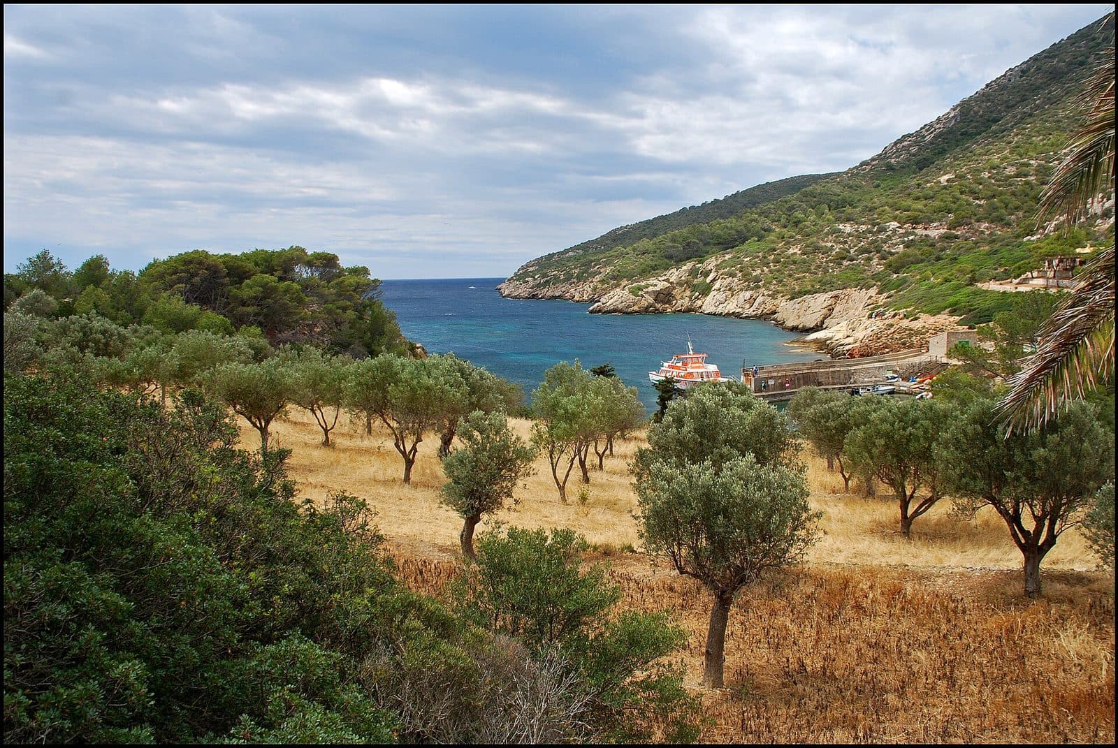
Na Miranda rewards visitors not with a view of Sa Dragonera, but with a view from the island back toward Mallorca. The viewpoint lies on the uninhabited rocky island off Sant Elm and forms part of a short circular walk beginning at Cala Lledó, the natural park’s harbor. From its terrace, the panorama opens across the Freu, the narrow sea channel between the two islands, toward the coast and the houses of Sant Elm.
It is precisely this reversal of perspective that makes the place special. From the Mallorcan shore, Sa Dragonera is usually seen as a dark, elongated silhouette. At Na Miranda, you stand on that silhouette and look back across the water. The excursion combines a boat trip, a manageable walk, and a clearly framed landscape view without requiring any of the island’s longer hikes.
At 1.12 kilometers, the circular walk is the shortest marked route on Sa Dragonera; the official walking time is 30 minutes. Along the way, there are former cultivated fields, a picnic area, and a stepped section. This suits families, wildlife watchers, and anyone with limited time on the island. Na Miranda is not an ordinary roadside viewpoint, however: the boat passage to Cala Lledó always lies between Sant Elm and the trailhead.
History and significance
Long before visitors followed marked trails through the natural park, the land around Cala Lledó was a human-managed landscape. Former agricultural areas can still be seen along today’s route. They are being restored to provide more suitable feeding grounds for seed-eating migratory birds. Na Miranda therefore tells a story not only of beautiful views but also of how historic cultural landscapes and modern conservation are connected on Sa Dragonera.
The agricultural landscape
The old cultivated areas lie around Cala Lledó, the natural harbor and starting point for the island’s trails. Their appearance differs from the steeper, rockier parts of Sa Dragonera: traces of organized, worked land remain visible here, although it is now managed according to ecological principles. The short walk thus passes through an area where the history of human use is not displayed in a museum but remains visible in the landscape itself.
This setting is essential to Na Miranda. The viewpoint does not stand in isolation on a bare summit but forms part of a small recreational and natural area with a trail, picnic facilities, and views toward the Mallorcan coast. Its significance lies precisely in this accessibility: it introduces the island to visitors who do not want to undertake an extended hike to the more distant lighthouses.
Closure and restoration
The viewing terrace was closed for more than three years. The closure was prompted by structural damage; during the subsequent renovation, a damaged concrete slab at risk of collapse was demolished. The terrace’s levels and paving were then adjusted. The work lasted six months and restored around 70 square meters of safely usable space at the viewpoint.
What is remarkable is not so much the scale of the intervention as the construction method chosen. Traditional dry-stone techniques were used for the renovation. Instead of presenting the platform as a conspicuous foreign object, it was integrated into the terrain with stone typical of the island. Today, Na Miranda therefore represents a sensitive approach to visitor management: the site makes the panorama accessible while allowing its materials and design to remain subordinate to the landscape.
What to see
The most striking view appears at the edge of the terrace. The Freu lies ahead, with the coast of Sant Elm extending beyond it. From here, the village from which Sa Dragonera appears like an offshore wall of rock is clearly seen within the broader landscape of southwestern Mallorca. Water, coastline, and settlement form several successive layers; depending on the light, either the rocky outlines or the village’s brighter surfaces stand out.
The Mirador de na Miranda
The usable viewing terrace covers around 70 square meters. Its levels and paving were adjusted during the latest renovation after damaged sections of the former slab had been removed. Dry-laid stone creates a visible connection with Mallorca’s traditional building methods.
Its small size is precisely what shapes the visitor experience. Na Miranda is more of a landscape balcony than a spacious plaza. After the short ascent, the view, previously restricted by the terrain, opens across the channel. Those who do not immediately continue will notice that the scenery can be read in both directions: toward the Mallorcan coast beyond the water and back into the relief of Sa Dragonera.
The Freu and the coast of Sant Elm
The Freu separates Sa Dragonera from Mallorca’s westernmost coastal area. At its narrowest point, the channel measures 780 meters. From Na Miranda, this separation becomes immediately clear: Sant Elm appears close, yet open water lies between the village and the viewpoint. Boats cross the same space that visually connects the two shores while physically separating them.
The coast of Sant Elm is the panorama’s main focal point. Behind it rise the foothills of the Serra de Tramuntana, while the water spreads out in front of the village. Unlike viewpoints on Mallorca, the view is not from the main island outward but from an offshore island back toward it. This makes Na Miranda one of the few places where Sant Elm’s position between sea and mountains can be understood from the opposite perspective.
The Puig de na Pòpia
From the trail and the viewpoint, the eye is also drawn toward Puig de na Pòpia, the highest point on Sa Dragonera. It reaches 353 meters and defines the island’s elongated profile. Na Miranda itself should not be confused with a summit hike: the short route remains in the area around Cala Lledó and presents the mountain as part of the island panorama without climbing to its highest point.
This contrast helps with orientation. On one side lies the inhabited coast of Sant Elm; on the other rises the rocky interior of the uninhabited island. The small, designed terrace sits between them. In a compact space, it captures what defines Sa Dragonera: rugged topography, traces of historic land use, and a protected natural area immediately off Mallorca.
Former cultivated fields and picnic area
The circular walk offers more than the viewpoint alone. It passes former agricultural fields around Cala Lledó that are being restored as feeding grounds for seed-eating migratory birds. This gives the walk a second focus. Alongside the sweeping coastal panorama, smaller structures catch the eye: divided plots, transitions between open terrain and vegetation, and traces of earlier land use.
A designated picnic area provides a place to pause in nature. It is particularly practical when the time remaining before the return boat is insufficient for another route. Food services are not part of the Na Miranda experience; the island remains a nature excursion destination. Anyone stopping here should bring food and, above all, water from Sant Elm.
Visiting Na Miranda
The excursion begins not at the viewpoint but at the pier in Sant Elm. Only after the crossing do visitors set out on foot from Cala Lledó. This sequence gives even the shortest route on Sa Dragonera the character of a small island adventure: coast, boat, natural park harbor, and circular walk are inseparably connected.
From Cala Lledó to Na Miranda
The marked route is the only circular walk on Sa Dragonera and also its shortest official route. The 1.12-kilometer trail has an official walking time of 30 minutes. Its highest section has steps. The walking time itself is therefore manageable, but additional time should be allowed for enjoying the terrace views, observing nature, and taking a break.
The trail passes through the area of the former cultivated fields and reaches the Mirador before returning to the starting area. Because both the beginning and end are at Cala Lledó, navigation is easier than on a point-to-point hike. Nevertheless, the return boat determines the day’s schedule. Before setting off, it is therefore worth checking the latest information at the harbor and the natural park’s current conditions.
Visit length and planning your day
Na Miranda is officially suitable for island visits intended to last no longer than one hour in total. This does not mean that travel and the boat trip are included; it refers to the short route on the island. Anyone who only wants to complete the circular walk and enjoy the view at leisure can keep the stay on Sa Dragonera compact. Because of the crossing and possible waiting times, however, the entire excursion from Sant Elm takes considerably longer than the walking time alone.
During the summer months, many day visitors come to Sant Elm, and some continue to Sa Dragonera. A sunset visit should not be planned without first confirming a reliable return journey: on an uninhabited island, the visit is governed by boat schedules, not solely by the desired light.
Opening and access
No fixed opening hours or mandatory admission fee are recorded for Na Miranda. Current information should be checked with the natural park or the boat operator departing from Sant Elm before the excursion. Several factors must be considered separately: access to the natural park, the condition of the trail, and the actual boat service.
The terrace was previously closed for an extended period because of structural damage and was subsequently renovated. For this reason in particular, current notices should be taken seriously and barriers must not be bypassed. The viewpoint is part of a protected natural area; visitors must remain on marked trails and follow the rules in force on site.
Getting there and parking
The road journey ends in Sant Elm. Na Miranda itself lies on Sa Dragonera and cannot be reached by car. From the coastal village, visitors travel by boat to Cala Lledó, the natural park’s harbor, where the 1.12-kilometer circular walk begins. Navigation directions suggesting that a road leads directly to the viewpoint are therefore misleading.
From Palma and the airport
Sant Elm is 37 kilometers by road from central Palma. The drive takes around 44 minutes, following the Ma-1 and then the Ma-1030. These figures expressly apply only as far as Sant Elm. Additional time must be allowed for the subsequent crossing to Sa Dragonera and the walk to Na Miranda.
From Palma Airport, the road distance to Sant Elm is 47 kilometers. The drive takes around 45 minutes via the Ma-20, Ma-1, and Ma-1030. Here too, the calculated driving route ends in the coastal village. The final stage consists of reaching the pier, taking the boat to Cala Lledó, and following the marked circular walk on the island.
Arriving in Sant Elm
Sant Elm lies at the end of the access road in Mallorca’s far southwest. During the busy summer season, many day visitors come to the village for its beaches, restaurants, and boat connections.
The S’Algar bus stop serves the Sant Elm area. Even when arriving by bus, the next steps remain the same: walk to the pier, cross to Cala Lledó, and continue from there on foot. Bus timetables and boat departures should be planned together, especially for the return journey. A missed connection cannot be managed as flexibly on an uninhabited island as in a resort town.
The final stage across the water
Sa Dragonera has no road connection to Mallorca. The boat passage is therefore not an optional addition but part of reaching Na Miranda. Cala Lledó is the island’s natural harbor, and the marked routes branch out from there. For Na Miranda, take the short circular route rather than one of the longer trails to the lighthouses.
By keeping the final return boat in mind, visitors can enjoy the terrace and picnic area without unnecessary time pressure.
Bus lines to Na Miranda at a glance
| Line | Route | Departures/day | First | Last |
|---|---|---|---|---|
| 121 | Sant Elm - Andratx | 98 | 07:10 | 21:32 |
From the official GTFS feeds (TIB/SFM), no real-time data. The figures cover all stops in the town; weekend and holiday services differ — check with the operator before travelling.
Getting there by bus
S'Algar (5017) · 1.8 km as the crow flies
- 121Sant Elm - Andratx · Daily
Sant Elm 2 (5014) · 2.3 km as the crow flies
- 121Sant Elm - Andratx · Daily
Sant Elm 1 (5015) · 2.3 km as the crow flies
- 121Sant Elm - Andratx · Daily
Timetable data: official GTFS feeds (TIB/EMT), no real-time — check with the operator before travelling.
Nearby places
Sant Elm is more than a mere transfer point. The former fishing village lies between the sea and the foothills of the Serra de Tramuntana. Sa Dragonera dominates the view from the coast, while Na Miranda reverses that exact perspective after the crossing. It is therefore worthwhile to look at the island first from the village and later identify that position on the opposite shore from the terrace.
Sant Elm
Historically, the village was known as La Palomera. The troops of King Jaume I anchored here before landing at Santa Ponça in 1229. Fishing and fish salting shaped the local economy for much of the 20th century; today, homes, smaller hotels, restaurants, beaches, and excursion traffic define the village.
For a combined day trip, Sant Elm provides the practical infrastructure absent from Sa Dragonera. Water and provisions can be purchased before the crossing, while the waterfront and beaches offer places to relax afterward. Sa Gran and Sa Petita are the village’s well-known sandy beaches; Cala es Conills adds a rockier stretch of coastline. Anyone combining the natural park visit with swimming should schedule both activities around confirmed boat connections.
Sa Dragonera
The island has been a protected nature reserve since 1995 and is uninhabited. Its western edge drops into the sea in high cliffs, while smaller coves and the harbor of Cala Lledó open along the eastern side. Na Miranda lies in the more accessible surroundings of this harbor and is therefore a good introduction to the natural park.
Longer routes open up other parts of Sa Dragonera, including lighthouses and historic structures. However, they should not be casually added to the short Na Miranda circular walk. Anyone wishing to see more of the island should plan a longer stay, bring sufficient water, and choose a route that safely connects with the booked or scheduled return boat.
La Trapa and the coastal landscape
On the Mallorcan side, La Trapa is one of the well-known nature and hiking destinations near Sant Elm. Torre de Cala en Basset also lies within this coastal landscape.
The connection is nevertheless already visible from Na Miranda: Sant Elm lies between a protected island, coastal mountains, and historic trails. Visitors who only see the terrace therefore receive not an isolated postcard view but a useful geographical introduction to Mallorca’s far southwest.
The place it belongs to
Sant Elm in the place guidePractical visitor information
The short trail should not be confused with a paved urban stroll. Its uppermost section has steps, and the excursion passes through a natural park on an uninhabited island. At 1.12 kilometers, however, the route remains manageable.
Water and food
The picnic area provides a place to enjoy food brought along, but it does not replace food services. It is best to purchase provisions and water in Sant Elm beforehand.
Visiting with children
The official natural park route is explicitly described as a suitable short excursion with children. Its circular layout, walking time of 30 minutes, and picnic facilities all support this recommendation. Adults should nevertheless bear in mind that the highest section has steps and that the excursion includes a boat trip.
Realistic time planning is especially important for families. The short hike does not automatically make the entire outing short: waiting times, the crossing, and the return journey must also be included. A sufficient buffer prevents a rushed return or the need to catch the last planned connection at the last moment.
What Na Miranda is not
Na Miranda is neither a roadside Mirador overlooking Sant Elm nor a viewpoint on the Mallorcan mainland. It lies on Sa Dragonera. Nor is it a summit hike or an observation tower with interior rooms and an exhibition. The experience centers on a small terrace, the view across the Freu, and the short natural park trail through the surroundings of Cala Lledó.
Those looking for dramatic elevation gains or a long day of hiking should choose another route on the island. Those who want to discover Sa Dragonera, understand the relationship between island and coast, and reach a striking viewpoint without an extended tour will find Na Miranda exactly the right route.
Local insider tips
Reverse the view
Look at Sa Dragonera from the shore of Sant Elm before departure, then look back from Na Miranda later: only this change in perspective reveals how narrow the Freu is between the uninhabited island and Mallorca.
Choose the short circuit
At Cala Lledó harbor, specifically follow the Na Miranda circular walk. At 1.12 kilometers and 30 minutes, it is the island’s shortest marked route and should not be confused with the longer trails to the lighthouses.
Look beyond the sea
The circular walk passes former cultivated fields that are being restored as feeding grounds for seed-eating migratory birds. They show that the surroundings of Cala Lledó were once a managed cultural landscape.
Pause before the return trip
The picnic area is a good place to spend the remaining time before the boat at a relaxed pace. Purchase water and a small snack in Sant Elm beforehand, as Na Miranda lies in a natural park without food services.
Confirm the return boat first
Before starting the circular walk, check the current return service from Cala Lledó. The trail is short, but Sa Dragonera is uninhabited and accessible only by boat; weather and sea conditions can determine the schedule.