
Llebeig Lighthouse on Sa Dragonera
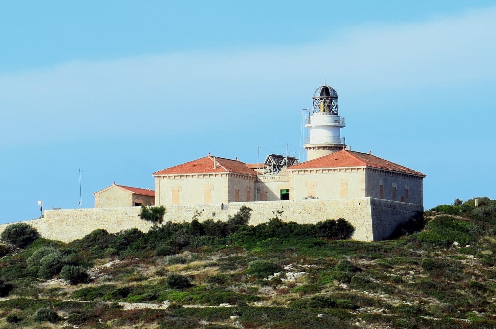

Llebeig stands where Mallorca seems very far away for a moment: at the outer end of the offshore island of Sa Dragonera, opposite Sant Elm. The historic lighthouse is not a quick roadside photo stop but the destination of an extended hike through the nature park. Even the journey across the sea makes it clear that this visit is different from most attractions on the island.
The route follows an old road across the slopes of Na Pòpia and along Puig dels Aucells. Views of Mallorca’s coast repeatedly open up along the way; at the destination, Far des Llebeig stands above the sea. The experience therefore consists of several parts: a boat trip, island scenery, a historic structure and the feeling of having reached a prominent Balearic outpost.
Llebeig is especially rewarding for hikers, nature-loving families and visitors who prefer to experience a lighthouse in its landscape rather than in an exhibition. The building itself is closed. Visitors should therefore not expect an interior tour, but rather a more demanding day trip involving a sea crossing and a longer route on foot.
History and significance
The lighthouse was designed by Eusebi Estada and inaugurated in 1910. It took over the role of the older Na Pòpia lighthouse, which had stood at the island’s highest point.
Eusebi Estada and the new lighthouse
Eusebi Estada designed the lighthouse. Its location still defines the character of the complex today. Llebeig does not stand in an established harbor district but far from any settlement on the uninhabited island. The old road now serves as a hiking route to the lighthouse.
Replacing Na Pòpia
Na Pòpia and Llebeig should not be confused. The older lighthouse stood on Sa Dragonera’s highest elevation; Llebeig was built at another point on the island and replaced it in its nautical role. Anyone hiking to Far des Llebeig is therefore not visiting the original lighthouse site on the summit, but its historic successor at the island’s outer edge.
The official route description sums up its nautical significance with a particularly vivid image: for ships heading toward the east coast of the Spanish mainland, Llebeig is the last light left astern. This function is immediately understandable from the hiking destination. There is no urban waterfront in front of the structure, only the open sea; behind it, Sa Dragonera recedes like a long ridge.
Beacon and coastal defense
Two eras of coastal protection meet in the surrounding area. In addition to the lighthouse, the official route also mentions Torre des Llebeig. This defensive tower is one of the fortifications intended to protect against attacks by pirates and corsairs. It is not part of the lighthouse, nor is it another name for it. This distinction is important: the tower represents military surveillance of the coast, while Far des Llebeig represents safe navigation for shipping.
Today, Llebeig lies within the natural landscape of Sa Dragonera and is a hiking destination whose significance still derives from its location. The structure is brought to life not by a museum presentation, but by the old road, the neighboring watchtower and the vast expanse of sea for which its light was created.
What to see
Only at the end of the long approach does Llebeig appear as a clear destination. The lighthouse stands on a steep cliff at the outer end of Sa Dragonera.
Far des Llebeig
The visible centerpiece is the historic lighthouse and its beacon. Because the building is closed, the visit focuses on the exterior. This is not an attraction where rooms or staircases are toured one after another. Instead, the structure is seen from outside as a technical outpost performing a service for shipping in this precise location.
Up close, it becomes clear just how isolated the chosen site is. A complete hiking stage lies between the island harbor and Llebeig; no public road from Mallorca reaches this point. The lighthouse can be reached on foot via the old road. Anyone standing in front of the building has arrived at a remote part of the island.
The beacon
The most important component should not be understood as an exhibit, but as a continuing nautical signal. Llebeig marks the transition from the sheltered island waters to the open sea west of the Balearic Islands. From here, you can mentally trace the direction of ships passing Sa Dragonera and setting a course for the Spanish mainland.
Especially during the day, when the signal itself is not the focus of attention, this context helps visitors interpret the site. Unobstructed views across the sea, the exposed cliff and the great distance from any settlement define the surroundings. Llebeig replaced the older Na Pòpia site.
The old lighthouse road
The route from Es Lledó to the lighthouse follows the old road. It runs along the slopes of Na Pòpia and Puig dels Aucells. The approach is therefore already part of what there is to see: the route leads to the remote lighthouse and repeatedly opens up views of Mallorca’s coast.
The road also provides a good sense of the excursion’s scale. Llebeig is not just beyond the landing stage, but at the end of a route totaling 9.224 meters there and back. The official route begins and ends in Es Lledó and adds up to 257 meters of ascent and the same amount of descent. Although the route is classified as easy, its length requires different preparation from a short coastal walk.
Torre des Llebeig
Torre des Llebeig adds a second historical highlight. The watchtower recalls a time when the offshore island and the coast near Sant Elm had to be monitored and protected against pirates and corsairs. The lighthouse and defensive tower served different purposes, but along the route they can be understood as parts of the same coastal landscape.
Anyone who looks closely at both structures can recognize a shift in perspective: the defensive tower was intended to spot dangers at sea as early as possible. With the lighthouse, the sea was understood not as the source of an attack but as a transport route where a reliable signal provided orientation.
The view back toward Mallorca
The official route specifically highlights the views of Mallorca’s coast. They accompany not only the destination but also long sections of the route. The changing direction of view is particularly appealing: on the outward journey, Llebeig draws hikers onward as a distant destination; on the return, the large island lies before them once again.
Sa Dragonera itself always feels like a distinct place. Sant Elm is the departure point for the crossing, but it is not where the lighthouse stands. Between the coastal village and Llebeig lie the sea, the Es Lledó landing stage and the long island route. This spatial separation is an essential part of the experience.
Visiting Llebeig
The visit begins not with the lighthouse but with the crossing. Sa Dragonera has no road connection to Mallorca and is reached by boat. After landing at Es Lledó, the hike begins along the old lighthouse road. Only then comes the stay at Llebeig, before visitors must return to the same starting point.
From Es Lledó to Llebeig
The official round-trip plan covers 9.224 meters and is listed as taking 2 hours 50 minutes of pure route time. It includes 257 meters of ascent and 257 meters of descent. These figures refer to the hike from and back to Es Lledó, not the journey to Sant Elm, the boat crossing or longer breaks at the lighthouse.
Llebeig should therefore be treated as an island excursion when planning the full day. The time available on land must fit the boat’s return schedule. Anyone who frequently stops to take photographs, examine Torre des Llebeig or spend longer looking out to sea at the destination will need additional time beyond the official walking duration.
Arriving at the lighthouse
The building is closed; visitors can see its exterior, its position on the cliff and the surrounding coastal landscape. The most memorable moment is often not simply arriving, but the point when the site’s function becomes clear: behind the lighthouse lies the long return route across the island, while the open sea stretches out in front of it.
It makes sense to establish the crossing and return times first and plan the hiking day around them. Sufficient daylight and a reliable time buffer are more important than hoping to arrive at a particular hour without crowds.
Time at the destination
The structure alone does not require a lengthy sightseeing itinerary because the interior is inaccessible. The duration of the stay depends on the views, photo stops and interest in the historic surroundings. The route and the landscape experience are clearly the main focus. Anyone who only wants to photograph an easily accessible lighthouse will underestimate the effort involved; those who enjoy hiking, however, receive a clearly defined destination and a historical context for the entire route.
Before departure, check the nature park’s current rules, any access requirements and, above all, the boat connections. The crucial question is not only whether the island can be reached, but whether there is enough time between arrival and the return crossing to complete the entire route.
Getting there and parking
The drive ends in Sant Elm. Llebeig itself stands on Sa Dragonera and cannot be reached by bridge or road. After arriving in the coastal village, visitors cross to the island landing stage at Es Lledó; only there does the walking route to the lighthouse begin.
From Palma
Sant Elm is 37 road kilometers from central Palma. The drive takes around 44 minutes and follows Ma-1 and then Ma-1030. These details apply explicitly only as far as Sant Elm. The boat crossing, waiting time and hike on Sa Dragonera must be added.
The final section leads into the coastal village, where the vehicle must remain. Because parking regulations and occupancy can vary by season, check before departure where parking is permitted in Sant Elm. There is no parking area at the lighthouse: on Sa Dragonera, the route is completed entirely on foot.
From Palma Airport
From Palma Airport, PMI, the road distance to Sant Elm is 47 kilometers. The drive takes around 45 minutes via Ma-20, Ma-1 and Ma-1030. Here too, the measured driving time ends in the village rather than at Far des Llebeig. For realistic day planning, allow separate time for finding your way around Sant Elm, reaching the landing stage, taking the sea crossing and completing the hike.
Boat and island route
From Sant Elm, the journey continues across the water to Sa Dragonera. The harbor where the hiking route begins is called Es Lledó. The old road to Far des Llebeig starts there and runs along the slopes of Na Pòpia and Puig dels Aucells. Both the outward and return routes end at the same landing stage, so the boat’s return time determines the schedule.
Because of the island location, there is no bus stop directly at the attraction; no stop is recorded in the immediate vicinity. Anyone wishing to travel to Sant Elm without a car should check current public transport connections to the village in advance and ensure that they coordinate with the boat timetable. Regardless of the chosen means of transport, the final stage always combines a boat trip and a hike.
Nearby places
Before the boat departs, Sa Dragonera lies like an elongated barrier off Sant Elm. The coastal village was once a fishing village and today depends primarily on tourism. Restaurants, bars, holiday homes and a small shopping area shape its appearance. For an excursion to Llebeig, however, Sant Elm is above all the gateway to the island and the place where the road journey transitions into a sea voyage.
Sant Elm
Sant Elm was formerly called La Palomera. The troops of King Jaume I anchored here before landing at Santa Ponça in 1229. Fishing and salting fish later shaped daily life. This maritime history makes an apt introduction to Llebeig: both the village and the lighthouse tell of a coast whose connections and dangers have always been determined by the sea.
After the return crossing, Sant Elm is a good place to take a break by the water. Depending on the time available, the sandy beaches of Sa Gran and Sa Petita, along with the smaller coastal areas of Cala es Conills and Cala en Basset, can be combined with the island excursion. Restaurants overlooking Sa Dragonera are also an obvious addition without requiring another long transfer.
Sa Dragonera
Llebeig is only one of the historic destinations on Sa Dragonera. Hiking trails provide access to the nature park, making it far more than a backdrop off Sant Elm. The official route to the lighthouse reveals the length of the island: from the Es Lledó landing stage along the old road to its outer edge.
Anyone considering additional island destinations should not automatically add them to the same day. The Llebeig route alone requires 2 hours 50 minutes of walking, excluding the boat trip and extended breaks. The current schedule of the sea connection remains decisive. On Sa Dragonera, a carefully chosen route is usually more sensible than trying to check off several widely separated destinations under time pressure.
La Trapa and Cala en Basset
On the Mallorca side, La Trapa and Cala en Basset are among the best-known destinations around Sant Elm. La Trapa dates back to a monastic community that founded a monastery there in 1810. Another historic defensive tower stands at Cala en Basset. Both places complement Llebeig thematically but require separate routes and are better considered alternatives or destinations for another day.
The place it belongs to
Sant Elm in the place guidePractical information for your visit
Llebeig rewards good preparation more than spontaneous haste. The destination lies on an uninhabited island, the building is closed and the official route covers 9.224 meters. Anyone who takes these three points into account will experience not a disappointing lighthouse stop, but a complete hike with a historic destination.
Footwear and route length
The route is officially classified as easy, but its length remains significant. The 257 meters of ascent and descent are spread across the outward and return routes; even with a moderate difficulty rating, the effort adds up when combined with the boat trip and breaks.
Sun and extra time
The route crosses an open island landscape to an exposed cliff. Nature and hiking are the main focus.
Visiting with children
The Consell de Mallorca lists the route as an easy family hike. However, that does not make its length irrelevant: 2 hours 50 minutes of official walking time, 9.224 meters and the need to return to the boat should all match the children’s stamina. Families should make sure to plan breaks and not begin the return journey only shortly before departure.
What not to expect
Llebeig is not an attraction with an accessible tower. The building remains closed. Visitors can see the exterior, the beacon in its scenic setting, the old road and the nearby historic coastal landscape with Torre des Llebeig.
Nor is it possible to drive directly to the site. The measured road routes end in Sant Elm; the journey then continues by boat and on foot. This remoteness is not an obstacle to be overcome as quickly as possible. It is the key to the place: Llebeig is compelling because it stands at the end of a long route and on the edge of the open sea.