
Mirador de la Trapa: Views of Sa Dragonera
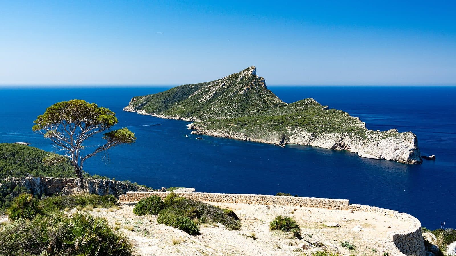

Mirador de la Trapa rewards the journey rather than a quick photo stop. Above Sant Elm, the coast opens up, and beyond the water Sa Dragonera lies in the sea like a long, rocky ridge. Cliffs, coves, and the foothills of the Serra de Tramuntana unfold around the island. This makes the viewpoint one of those places in southwestern Mallorca where the landscape and the experience of reaching it are almost impossible to separate.
The name itself points to more than the view. La Trapa was an agricultural valley landscape for centuries and later became a Trappist retreat. Around the Mirador, ruins, dry-stone walls, terraces, and water-collection structures reveal how arduous life was in this remote terrain. Here, the sea view is not set against a neutral backdrop but lies at the heart of a historic cultural landscape.
For hikers, the Mirador is a natural destination on a route from Sant Elm. Anyone expecting an easily accessible roadside viewing platform, however, is in the wrong place: the viewpoint must be reached on foot, and the trails can be rocky, steep, and confusing in places. This very seclusion shapes the experience. With every metre gained, the coastal village recedes farther into the distance while Sa Dragonera increasingly dominates the composition of the panorama.
The site is particularly rewarding for visitors who want to combine views, hiking, and Mallorcan cultural history. The experience includes more than the minutes spent at the Mirador; it also involves reading the landscape: earth held back by walls, old working areas, the monastery ruins, and the visible need to conserve every drop of water.
History and Significance
The history of the La Trapa valley did not begin with the monastery. Its sheltered location had already been used for agriculture for centuries before members of a religious order arrived. The terraces and walls that now seem like natural parts of the mountainside were working tools: they retained soil, created usable areas, and made it possible to cultivate an otherwise dry, steep landscape.
The Trappists of La Trapa
Trappists settled in the remote valley. The monks had fled France as a result of the French Revolution. For an order whose daily life was shaped by prayer, silence, and physical labour, La Trapa offered a suitable retreat: far from larger settlements, difficult to reach, and yet with enough land to establish a largely self-sufficient community.
During their stay, the Trappists built a monastery and continued to develop the existing cultural landscape. Dry-stone walls and terraces were created using traditional construction techniques, while water had to be collected in storage galleries. None of this was decorative, as the structures served the basic needs of a place where fertile soil and water were not readily available.
From Workplace to Landscape of Ruins
The monastery has not survived in its entirety. Its ruins now form the historical backdrop to Mirador de la Trapa, although the viewpoint and monastery should not be treated as the same place. It is precisely their coexistence that makes the site understandable: before the sea view lie the remains of a community that saw this landscape not as a panorama, but as a place to live and work.
Among low stone buildings, walls, and former agricultural areas, it is still possible to see how closely the architecture responded to the terrain. The terraced slopes follow the contours of the valley; water-collection structures preserved rainfall before it could flow unused into the sea. Visitors today are therefore looking at a landscape that was shaped over a long period rather than simply inhabited.
La Trapa as a Protected Natural Area
Today, the estate is owned by the Mallorcan nature and bird conservation organisation GOB. La Trapa is private property but is kept accessible for responsible public visits. Nature conservation, historic architecture, and hiking come together directly here. The absence of permanent visitor staff on the site makes considerate behaviour especially important.
The Mirador therefore has a significance that extends beyond its photographic perspective. It opens up views of Sa Dragonera and the southwestern coast while also drawing attention back to the vulnerable landscape behind the viewer. Those who stay on the marked trails, take their rubbish away, and preserve the peace are not protecting just any interchangeable viewpoint, but a place whose history has been shaped by scarce resources.
What to See
Sa Dragonera is the first thing to draw the eye. The offshore island stretches across the coast and, with its irregular silhouette, resembles a resting dragon. From Mirador de la Trapa, it appears not as a distant detail on the horizon but as the main subject of the panorama. Depending on the vantage point, the cliffs, the open Mediterranean, Cala en Basset, and parts of the area around Sant Elm also come into view.
Sa Dragonera
The perspective of Sa Dragonera is the main reason to climb to the Mirador. From the mainland, the island is often seen only from sea level; from up here, by contrast, its entire elongated shape becomes clear. A broad expanse of water lies between the viewpoint and the island, while the cliffs on both sides frame the view. In clear conditions, the rugged contours are particularly easy to follow.
For photographs, it is worth doing more than pointing the camera directly at the island. Including part of the rocky coast or a dry-stone wall in the foreground shows why this view feels different from one seen from the beach. Sa Dragonera then appears not in isolation at sea, but as part of a larger coastal landscape defined by steep slopes and deeply cut coves.
The Coast of Sant Elm
Looking in the opposite direction reveals how far the climb from Sant Elm has taken you. The coastal village remains behind as a bright, compact settlement by the water, while the terrain in between divides into woodland, rocks, and mountain slopes. This perspective explains the location of Sant Elm on Mallorca’s western edge better than any map: the sea lies open before the village, while the mountains begin almost immediately behind it.
Cala en Basset also belongs to this wider landscape. The cove and the coastal section of the same name appear between rocky edges and slopes. Those who include the Mirador in a longer hike experience this coast from several elevations and directions. The view changes continuously, but Sa Dragonera remains the reliable point of orientation out on the water.
The Viewing Area
The circular viewing area blends into the rocky terrain and derives its impact from its exposed position. The effect comes from the contrast between the limited space underfoot and the vast expanse of sea ahead. Below and around the monastery grounds, there are further viewpoints, but they should be approached only by using clearly recognisable trails. Shortcuts across the slope damage the fragile surface and can be dangerous on loose, rocky ground. The best vantage point is therefore not the outermost reachable rock, but a safe place where the coast, island, and historic landscape can all be included in the same image.
Terraces and Dry-Stone Walls
Looking away from the sea reveals a geometric order within the seemingly wild terrain. Dry-stone walls run along the slopes, support terraces, and mark out former working areas. They were built without mortar from carefully positioned stones and follow a construction method characteristic of the cultural landscape of the Serra de Tramuntana.
At the Mirador, these walls vividly illustrate the relationship between people and the terrain. Where a natural slope would quickly lose soil and rainwater, the layers of stone create small level areas. Some are now overgrown, but their lines remain visible. The panorama therefore consists of two layers of time: the geological shape of the coast outside and the mountain landscape reshaped by people in the foreground.
Monastery Ruins and Working Areas
The ruins of the former Trappist monastery lie near the viewpoint. Surviving stone buildings and low sections of wall mark the community’s former living quarters. There are also traces of traditional agriculture, including a type of mill powered by animals and a threshing floor. They show that La Trapa was not solely a religious retreat but also a working estate.
The water-supply structures deserve particular attention. Storage galleries were used to retain water in this dry environment. Together with the terraces and walls, they formed a system: collecting water, securing the soil, and making land usable. Those who examine these features before walking to the Mirador will see the view differently afterwards. The remoteness then appears not only picturesque, but also demanding.
Visiting Mirador de la Trapa
A visit begins not at the viewpoint, but with the choice of hiking route. Most hikers climb from Sant Elm to La Trapa. This connection is shorter than the alternative from Coll de Sa Gramola, but requires care on rocky and steep sections. Depending on the chosen variation, the trail passes through woodland, follows stony paths, and crosses short secured sections.
Ascent from Sant Elm
From Sant Elm, first head towards Avinguda de la Trapa and Camí de Can Tomeví. Beyond the edge of the village, the character of the route changes: the asphalt and houses fall behind, the surface becomes unpaved, and the terrain climbs into the hills. Markers and signposts help on some sections, but in less obvious passages, you should not rely solely on taking spontaneous turns.
The route is more than a short walk. Several hours should be reserved for the outward journey, time at the site, and the return. Those who frequently stop for photographs, examine the historical traces, or want a longer break at the Mirador should allow correspondingly more time. The descent demands the same concentration as the ascent, because loose stones and steep sections do not become easier when heading downhill.
Route from Coll de Sa Gramola
A longer alternative begins at Coll de Sa Gramola on the Ma-10. It follows sections of the marked dry-stone route GR 221 and the Camí de ses Basses. The route connects La Trapa with the viewpoints Les Bardes and Mirador d’en Josep Sastre. For the return route, the available description gives a distance of 14,3 kilometres, four hours, and 496 metres of elevation gain.
This option is suitable for hikers who want not only to reach Mirador de la Trapa but also to experience a larger stretch of coast from above. However, it passes through a designated hunting area. Signs such as “Caça major”, “Coto de Caza”, or “No Sortiu del Camí” must be taken seriously: do not leave the marked trail, and keep dogs on a lead.
Time of Day and Crowds
An early start offers two advantages: experience suggests that fewer hikers are on the trails, and there is enough daylight for the ascent, a break at the viewpoint, and a safe return. The exposed position of the Mirador offers little protection from intense sunlight, while the wooded access sections provide occasional shade. Spring and autumn are recommended as particularly suitable seasons for the longer hiking route.
At the viewpoint itself, it is worth resisting the urge to turn around immediately. Even a small change of position alters the way Sa Dragonera, the cliffs, and the dry-stone walls overlap. Quiet is part of the site’s visitor ethos. Loud music and shouting disturb other hikers and conflict with the explicitly requested respectful treatment of the natural environment.
Current access and visitor information from the owner should be checked before setting out. There are no permanent staff on site, and conditions on hiking trails can change. The Mirador is therefore not a destination where you should wait until reaching the trailhead to think about the weather, equipment, and return route.
Getting There and Parking
The stated driving routes lead to Sant Elm, not to Mirador de la Trapa. From the coastal village, the viewpoint is reached on foot. This is essential for planning: the drive is only the first stage, followed by a hike lasting several hours with elevation changes and rocky sections.
From Palma
From the centre of Palma, the road distance to Sant Elm is 37 kilometres. The drive takes around 44 minutes and follows the Ma-1 and then the Ma-1030. The road initially heads towards the island’s southwest before reaching the coastal village through the Andratx and s’Arracó area.
The motorised journey ends in Sant Elm. For the walking route, head towards Avinguda de la Trapa and Camí de Can Tomeví. Anyone planning a circular hike should decide before setting out which route variation to use for the outward and return journeys. Spontaneous shortcuts are not a good alternative in confusing terrain.
From Palma Airport
The road distance from Palma Airport to Sant Elm is 47 kilometres. The drive takes around 45 minutes via Ma-20, Ma-1, and Ma-1030. This figure also applies only as far as the village. The Mirador is neither on the main road nor at a viewpoint accessible by car.
The total excursion time must therefore include not only the drive, but also finding a parking space, preparation, and the hike. Particularly when arriving late in Sant Elm, check whether enough daylight remains for the ascent, time at the site, and a careful descent.
Parking and the Final Section
Vehicles should not be left in access points or along narrow roadsides. During busier periods, it is sensible to allow extra time to find a parking space and to have hiking equipment ready. There is no bus stop directly at the viewpoint either. Anyone reaching Sant Elm by public transport must complete the same hike for the remainder of the route and allow sufficient time for the return timetable. Limited mobile reception across large parts of the terrain makes it advisable to organise the route and return journey before setting out rather than along the way.
Nearby Places
After the descent, Sant Elm feels almost like the opposite of La Trapa. Above, walls, rocks, and the open coast dominate the scene; below, houses, beaches, and restaurants lie directly beside the water. The former fishing village belongs to the municipality of Andratx and forms the natural starting point for excursions along Mallorca’s western edge.
Sant Elm
Until the early twentieth century, Sant Elm relied mainly on fishing and the processing of salted fish. Today it is a small holiday destination but has retained its compact structure. Sa Dragonera can also be seen from the waterfront, allowing hikers to view the island again from a significantly lower perspective after the walk.
Spending time in the village works especially well after the route. Rather than getting straight into the car, the day can wind down by the water. The transition from the rocky mountain trail to the coast once again reveals the height and distance covered during the hike.
Sa Dragonera
The island that dominates the panorama from the Mirador is now protected as a nature park. The two perspectives complement one another: from the Mirador, the island’s overall shape becomes visible, while on Sa Dragonera itself, its landscape takes centre stage. Combining both on the same day should only be considered if timetables, weather, and hiking time can be coordinated safely. Visiting the Mirador is already a substantial excursion in its own right and should not be placed under time pressure.
Cala en Basset and Torre de Cala en Basset
Cala en Basset and the historic watchtower Torre de Cala en Basset lie within the same coastal landscape. Several circular hikes connect these points with La Trapa and Sant Elm. The tower adds a cultural and historical dimension, while the cove opens up another perspective of the rocky southwestern coast.
Such a circuit is more demanding than a simple outward-and-return route. Sections can be steep and follow unpaved paths. Anyone visiting Mirador de la Trapa for the first time or with limited experience on rocky terrain is better served by a clearly planned route and sufficient time than by attempting to include as many additional destinations as possible.
Les Bardes and Mirador d’en Josep Sastre
Les Bardes and Mirador d’en Josep Sastre lie on the longer route from Coll de Sa Gramola. Both add further coastal views to the hike, but they do not replace Mirador de la Trapa: only at La Trapa is the view of Sa Dragonera so closely combined with the historic landscape of terraces and monastery ruins.
The route is well suited to experienced hikers who want to explore a larger section of the GR 221 and Camí de ses Basses. As the trail partly passes through hunting grounds, the signposted route and all local warnings must be observed.
The place it belongs to
Sant Elm in the place guidePractical Information for Your Visit
The remoteness that makes the Mirador so appealing also requires preparation. La Trapa is not a serviced viewpoint. There is no drinking water on site and no regular rubbish collection. Everything needed must be brought along, and all waste must be taken away again.
Footwear, Water, and Weather Protection
Sturdy hiking boots with good grip are advisable on the rocky and sometimes steep trails. Sandals or smooth-soled casual shoes provide little security on loose ground. The backpack should also contain enough drinking water as well as protection from the sun and weather. The open areas around the Mirador can be heavily exposed to sunlight, while conditions in the mountains may quickly feel very different from those below in Sant Elm.
As mobile reception is poor and may be entirely absent across large parts of the estate, a map or offline route should be available. Setting a planned return time helps prevent being caught out by nightfall. Anyone hiking alone should ideally leave another person a brief note about the route and destination.
Marked Trails and Nature Conservation
Shortcuts must explicitly be avoided in La Trapa. They encourage erosion, damage vegetation, and often cross poorer ground than the signposted trail. Old terraces and walls should not be treated as climbing or seating areas either; they are historic traces of labour and, in some cases, fragile structures.
Dogs may enter the site only when kept on a lead. This protects wildlife, other hikers, and the dog itself. This caution is especially important on routes through designated hunting areas. Warning signs along the trail are not general decoration but specific information about local use.
Visiting with Children
For families, the Mirador is a suitable destination only when children are accustomed to longer climbs, rocky trails, and an equally focused return journey. Short secured passages and steeper sections require sure footing and close supervision. This is not a route for a pushchair or a spontaneous walk after visiting the beach.
Breaks should be taken in wide, safe places rather than directly beside steep drops. Sufficient water, sun protection, and energy reserves for the return journey are especially important for children. The historic walls, terrace system, and clearly visible island of Sa Dragonera provide many engaging points of interest along the way, so the hike does not have to be solely about reaching the final view.
What Not to Expect
There is no drinking water at the Mirador, nor is there a permanently staffed information point. The explanation of the site lies in the terrain itself: in the ruins, dry-stone walls, water-storage structures, and the relationship between the cultural landscape and the sea.
For this very reason, the Mirador should not be treated like an ordinary viewing platform. Those who arrive prepared, allow enough time, and explore the site quietly will experience more than the view of Sa Dragonera. They will also see how generations of people made a remote, dry mountain landscape usable—and how much care is needed to preserve the traces they left behind.
Local insider tips
Frame the Dragon
For the most characteristic image, do not simply zoom in on Sa Dragonera: including part of the cliffs or a dry-stone wall in the foreground reveals the Mirador’s elevated position and connects the island, sea, and cultural landscape.
Start Early in Sant Elm
An early departure means quieter trails and enough daylight for breaks at the viewpoint and the descent. Because the route takes several hours, the Mirador should not be approached late in the day.
Remember to Look Behind You
Sa Dragonera immediately draws the eye. The often-overlooked details lie behind and beside the viewpoint: terraces, dry-stone walls, and traces of water collection explain how La Trapa was made habitable.
Two Routes, Two Experiences
The route from Sant Elm is shorter and steeper. The longer route from Coll de Sa Gramola follows GR 221 and Camí de ses Basses, also including Les Bardes and Mirador d’en Josep Sastre.
Save the Map Offline
Mobile reception is weak or absent across large parts of La Trapa. A route saved in advance is therefore more useful than hoping to resolve confusing junctions by smartphone along the way.