
Talaiot de sa Nineta near Son Serra de Marina
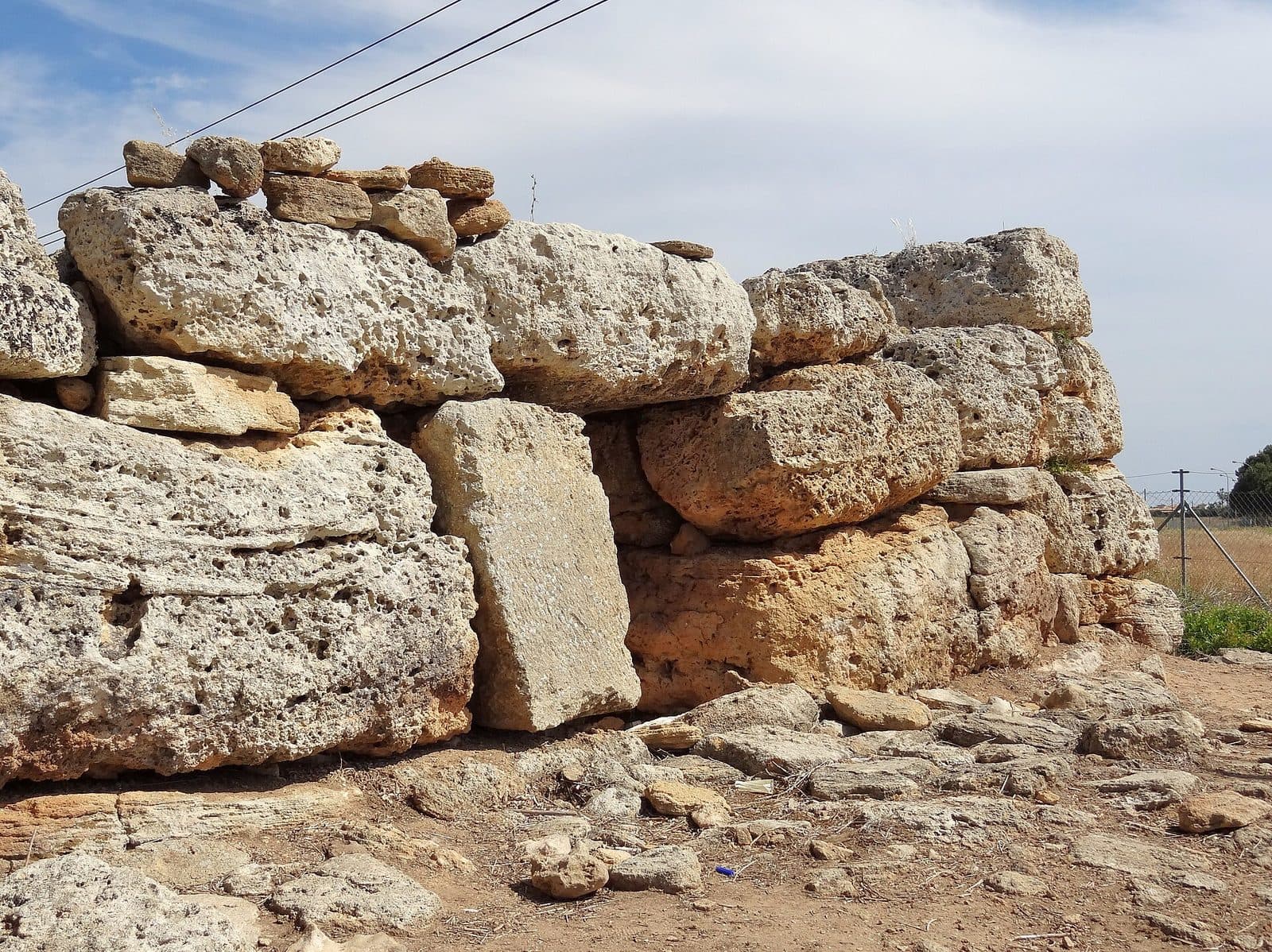

Traveling from Mallorca’s interior toward the Bay of Alcúdia, you encounter a structure from a far older world at the turnoff to Son Serra de Marina. The squat stone building rises directly beside the road—compact, enigmatic, and therefore surprisingly easy to overlook.
Its full name is Talaiot de sa Cova de sa Nineta; the site is often referred to simply as Talaiot de sa Nineta. It is a prehistoric tower on the Son Serra estate in the municipality of Santa Margalida. It belongs to Mallorca’s Talaiotic culture and is particularly notable for its preserved lower masonry and striking entrance.
A visit is worthwhile less as a full evening’s excursion than as a focused encounter with the island’s prehistory. Large stone blocks, the ruin’s low profile, and visible traces of later restoration tell several stories at once: of the people who built it, the gradual loss of its upper sections, and the modern attempt to secure the surviving masonry. Travelers who want to discover more of Mallorca than beaches and villages will find this an accessible introduction to the island’s archaeology. The Talaiot also combines well with Son Serra de Marina, the coast, and the landscape of Son Real.
History and significance
The Talaiotic period
Long before the present road to Son Serra de Marina was built, Talaiotic communities shaped Mallorca’s landscape. Talaiot de sa Nineta is attributed to the Bronze Age Talaiotic culture, which flourished on the island from 1300 to 123 BC. Its massive masonry therefore belongs to an architectural tradition whose stone towers remain among the most striking testimonies to Mallorca’s prehistory.
The name Talaiot is related to the Mallorcan word for a tower or watchtower. However, the modern designation should not lead to a hasty interpretation. Researchers discuss various possible purposes for talaiots, including communal use, control of the surrounding area, and defense. No single function has been conclusively established for Talaiot de sa Nineta, so its precise role within the settlement landscape of the period remains uncertain.
This unresolved chapter is exactly what makes the site interesting. The surviving masonry demonstrates a considerable investment of labor but does not reveal what activities once took place inside or around the tower. The building was more than a random accumulation of stones: its clear ground plan, the orientation of its entrance, and the careful placement of large blocks show deliberate construction. The social significance associated with it can no longer be read fully from the stone alone.
The loss of the upper sections
Today, mainly the lower part of the talaiot survives. Its original height and the precise design of the missing upper sections are no longer directly apparent from the present remains. As a result, the structure resembles a heavy mass of masonry almost fused with the ground rather than a rising tower. This squat appearance should not be mistaken for its original form; it is the result of a long history of survival and loss.
This distinction is important when viewing the site. The ruin is not a completely preserved prehistoric building but its most durable core. The massive lower courses of stone survived, while the higher sections disappeared. The talaiot is therefore both monument and fragment: it conveys the strength of the original construction while leaving essential questions about its height, top, and internal design unanswered.
The restoration of 1968 and 69
Another chapter began in 1968 and 69. Under the direction of Joan Camps Coll, the talaiot was reconstructed and consolidated. For reasons beyond his control, the work remained unfinished. Surviving documents, diaries, drawings, and photographs later made it possible to trace this intervention.
The structure’s present appearance is therefore not exclusively prehistoric but also reflects restoration decisions. This is particularly relevant at the entrance, where a vertical stone arrangement stands out, while comparable talaiots would more typically be expected to have slabs laid one above another. An archaeological account suggests that this feature probably resulted from an incorrect reconstruction during the work at that time.
Talaiot de sa Nineta thus also tells the story of changing approaches to archaeological monuments. The restoration helped stabilize the surviving structure and keep it visible, but it also created a section that must be interpreted critically. A careful observer is looking not only at prehistory but also at a modern idea of how a damaged monument should be made understandable again.
What to see
The ground plan
The basic form is easiest to grasp from a short distance, even though vegetation, soil cover, and the loss of higher sections of masonry make the original outline less distinct in places. It is worth slowly changing your viewing angle: from the front, the ruin initially appears to be a solid block. The eastern corner is an especially good point from which to examine the wall’s construction and the compact volume of the structure. From here, it also becomes clear why the talaiot still has such a powerful physical presence despite its limited height today.
The ground plan is more than an archaeological classification. It determined how the building appeared in the landscape and how its sides related to the entrance. Because only the lower section survives, this arrangement is easier to understand by walking around the structure than from a single viewpoint. Anyone who immediately heads straight for the portal may overlook how precisely the building as a whole was laid out.
The cyclopean masonry
The outer walls were built from large stones using cyclopean masonry. The term does not describe the work of mythical giants but a construction method in which exceptionally heavy blocks are assembled into massive walls. At Talaiot de sa Nineta, this technique can be clearly observed in the surviving lower section. The individual stones are irregular, yet together they form a dense, durable wall.
From close up, attention is drawn almost automatically to the joints. The wall does not depend on the uniform rows of modern ashlar masonry but on the interaction of differently shaped blocks. Their size, weight, and position had to be coordinated. At the corners in particular, it becomes clear how the stones accommodate the change in direction of the outer wall and give the building stability.
Several worked blocks and the lintel make parts of the talaiot appear more regular than the term cyclopean masonry might initially suggest. Rough mass and deliberate workmanship meet here. The craftsmanship lies not in decorative ornament but in the organization of the material: every large stone performs a structural function. The masonry also helps explain why the lower section survived the loss of the upper parts, as the remaining fabric appears heavy and resilient.
The portal on the southeast side
The entrance is on the southeast side. The portal is the most distinctive individual feature of the structure. It interrupts the massive outer wall and draws the eye toward a darker opening, although no fully preserved interior can be discerned from it. The contrast between the heavy wall and the narrow passage makes this viewpoint especially revealing.
Worked stones and a lintel are visible at the entrance. They show that the building did not consist merely of piled fieldstones. The opening had to be planned, spanned, and integrated into the weight of the surrounding wall. Viewing the portal first from the front and then from the side makes it easier to appreciate how deep the wall appears in relation to the opening.
At the same time, this particular section must be interpreted with caution. The vertical pilaster-like feature at the entrance is probably the result of an inaccurate reconstruction from the late 1960s. The detail is easy to miss, but it changes how the entire site is perceived. Not everything that appears especially orderly or unambiguous today necessarily survives in exactly this form from prehistoric times.
Preserved core and restored additions
The most rewarding tour therefore involves comparison. On one side are the irregular, weathered courses of the surviving core; on the other are sections whose present arrangement was influenced by consolidation and reconstruction. The talaiot reveals itself through careful observation: the ground plan, corners, masonry bonds, portal, and lintel are the key elements. Together, they gradually create a picture of the original building. Anyone who takes the time to study them will discover more than they would from a quick roadside photograph.
Its incompleteness is precisely what sharpens the eye. The monument requires visitors to distinguish between what is visible and what has been lost. The heavy lower walls are physically present; the original height, top, and many details of its use remain beyond direct observation. This boundary is part of the visitor experience, not a weakness of the site.
Visiting the site
Approaching from the road
The first impression is often unexpected. The talaiot stands directly beside the country road at the turnoff toward Son Serra de Marina, appearing as a compact stone structure next to the modern traffic route. Passing vehicles and prehistoric masonry are unusually close together here.
This location makes a visit straightforward, but it also requires attention. The best way to experience the structure is not through a hurried glance from a vehicle. Only on foot can the ground plan and the different sides be meaningfully compared. Because road traffic is part of the present-day surroundings, particular care should be taken to remain in safe areas when approaching the site and changing viewpoints.
A visit consists of looking, comparing, and interpreting. This makes the experience independent and immediate, but it also requires a little prior knowledge or a willingness to engage with the details of the masonry.
A walk around the structure
A simple sequence works well for exploring the site. First, view the talaiot from a short distance so that its ground plan becomes legible. Then focus on the corners and the large courses of stone. Finally, examine the southeast portal, with its lintel and striking vertical stone arrangement.
This order prevents attention from narrowing solely to the entrance. The talaiot’s true distinction lies in the interaction of its structural elements. The portal is important, but only the surrounding walls make clear how massive the building as a whole once was. Its surviving height is also easier to assess by comparing the different sides.
The length of a visit therefore depends heavily on personal interest. As a compact, standalone site, the talaiot is suitable for a manageable stop along the way. Anyone interested only in its external form will finish quickly; those who compare the masonry bonds, corners, restored portal, and roadside setting can spend considerably longer. A fixed visiting time would not do the site justice.
Planning and timing your visit
Reliable visiting hours and admission conditions should be checked before setting out. The talaiot is not a site where older information from travel portals should be accepted without question. Daylight is helpful for the visit itself, as it makes the wall joints, worked stone, and differences between the various sides easier to see.
No reliable pattern of particularly busy or especially quiet times of day has been documented. Given its roadside location, the atmosphere depends not only on other visitors but also on passing traffic. Anyone wishing to take photographs or study the building carefully should allow enough time to choose a safe viewpoint rather than relying on a supposedly ideal moment.
The talaiot is particularly suitable as part of a day trip. Its compact form and location on the way to the coast make it easy to combine this archaeological stop with Son Serra de Marina or the landscape of Son Real. This gives the brief visit a broader context: from the prehistoric tower, the journey continues to the coast.
Getting there and parking
From Palma Airport
The stated route information leads to Son Serra de Marina, not to the final position directly beside the talaiot. The road distance from Palma Airport to Son Serra de Marina is 67 kilometers. The drive takes around 71 minutes and follows the Ma-30, then the Ma-13 and the Ma-3400.
The talaiot itself stands at the beginning of the road leading to the coast, near the turnoff to Son Serra de Marina. The final section therefore follows the approach to the town. Avinguda del Talaiot de sa Nineta, named after the structure, continues toward the coast and ends at the harbor of Son Serra de Marina. The historic landmark thus remains a reference point in the local road network today. As you approach, look for a small archaeological structure beside the road.
From central Palma
The road distance from central Palma to Son Serra de Marina is 64 kilometers. The drive takes around 75 minutes. The route follows the Ma-13, the Ma-3400, and the Ma-3440. These details also refer to Son Serra de Marina; the talaiot stands on the approach road or at the turnoff to the coastal town.
Planning should take more than the distance into account. At the end of the journey, the route leads from the island’s interior into the more rural road network of the north, where the stone structure appears directly beside the modern road.
By bus
The bus stop is named Talaiot de sa Nineta and is listed under identifier 55042. This makes it possible in principle to include the site in a journey to Son Serra de Marina without a private car. Current routes, operating days, and connections should be checked before departure, as timetables can change.
The proximity of the bus stop, turnoff, and monument also highlights the talaiot’s unusual location: it is not a remote destination in open country but part of a landmark now strongly shaped by traffic. When getting off the bus and approaching the site, the road deserves as much attention as the structure itself.
Bus lines to Talaiot de sa Nineta at a glance
| Line | Route | Departures/day | First | Last |
|---|---|---|---|---|
| 316 | Son Serra - Inca | 68 | 06:25 | 22:55 |
From the official GTFS feeds (TIB/SFM), no real-time data. The figures cover all stops in the town; weekend and holiday services differ — check with the operator before travelling.
Getting there by bus
Talaiot de sa Nineta 2 (55041) · 1.6 km as the crow flies
- 316Son Serra - Inca · Daily
Talaiot de sa Nineta 1 (55042) · 1.6 km as the crow flies
- 316Son Serra - Inca · Daily
Son Serra centre (55044) · 2.1 km as the crow flies
- 316Son Serra - Inca · Daily
Timetable data: official GTFS feeds (TIB/EMT), no real-time — check with the operator before travelling.
Nearby attractions
Son Serra de Marina
The road branching off at the talaiot leads to Son Serra de Marina on the Bay of Alcúdia. The name Son Serra originally referred to an estate extending along the coast between Torrent de Son Real and Torrent de na Borges. Both seasonal streams flow from the island’s interior to the sea, framing a landscape where coastline, dunes, and an ancient cultural landscape follow closely one after another.
Avinguda del Talaiot de sa Nineta recalls the prehistoric structure within the townscape and ends at the harbor. The talaiot can therefore be understood as a natural starting point for a visit to Son Serra de Marina. From the archaeological stone structure, the route follows the road named after it to the coast—a vivid transition from prehistoric Mallorca to the present-day coastal town.
Son Serra de Marina is not essential for understanding the talaiot, but it adds a landscape setting to the visit. The structure did not stand in an abstract historical void but belonged to an area shaped by routes, watercourses, and proximity to the coast. Although the precise relationships of that period cannot be reconstructed, continuing to the sea makes its location in northern Mallorca immediately tangible.
The coast of Son Real
To the west lies the landscape of Son Real. Its coastal paths, beaches, and archaeological traces make it a natural destination to visit afterward. A hiking route leads from the Son Serra de Marina area via the talaiot, Torrent des Revellar, Platja de Son Real, and Platja de s’Home Mort. The talaiot can therefore become one stop in a broader day exploring the landscape.
A visit to the necropolis of Son Real is an especially fitting combination. Its tombs include forms that echo smaller navetas and talaiots. Some are round, while others have square ground plans. Without first seeing Talaiot de sa Nineta and the basic forms of Talaiotic architecture, this connection can remain more abstract. The brief roadside stop can therefore serve as visual preparation for the more complex archaeological landscape on the coast.
A detailed portrait of the necropolis would go beyond the scope of a visit to the talaiot. For planning purposes, a simple distinction is sufficient: Sa Nineta presents a massive prehistoric tower, while Son Real leads into a funerary landscape containing numerous tombs and different burial rites. The two sites tell different chapters of the island’s prehistory.
Beaches and coastal paths
Platja de Son Real and Platja de s’Home Mort can be included as scenic additions. After carefully examining wall joints, the portal, and courses of stone, the scale changes there: instead of a single building, the focus shifts to the coastline, paths, and transitions between sea and land.
This combination is particularly suitable for travelers who do not want to view archaeology in isolation. The talaiot itself remains a compact stop, while the coast offers space for a longer walk. The result is an excursion in which the stone tower is not overshadowed by other monuments but becomes easier to understand through its landscape context.
The place it belongs to
Son Serra de Marina in the place guidePractical information for your visit
Footwear and terrain
Sturdy shoes are advisable for the visit. This is especially true if the talaiot is combined with a route toward Son Real or the beaches.
Visiting with children
For children, the talaiot can provide an accessible introduction to prehistory because there is no display case between the viewer and the structure. The size of the stones and the darker portal opening can be explored directly. A simple observation task—comparing large and smaller blocks or looking for the entrance—makes the site easier to understand than a lengthy chronological explanation.
However, its location directly beside the road requires close supervision. Anyone combining the stop with a hike should choose footwear and assess stamina according to the route that follows, not only the compact visit to the talaiot.
Photography and close observation
For a clear photograph, an angled viewpoint is generally more useful than a strictly frontal shot. From there, a corner, an outer wall, and part of the portal can be captured together. The image then shows the structure as a whole rather than a single surface of stone. The wall’s construction is particularly easy to read at the eastern corner.
Close-up photographs are worthwhile at the southeast portal. The lintel, worked blocks, and striking vertical stone arrangement tell of both prehistoric construction and later restoration. Anyone taking only a quick souvenir photograph from the roadside may miss the very detail that most clearly illustrates the modern reconstruction.
What not to expect
The tower’s specific historical use cannot be reduced to a single confirmed function. Its value instead lies in its concentration of features: massive cyclopean masonry, a southeast-facing portal, and the visible consequences of an unfinished restoration are enough to reveal several layers of time. Visitors who do not judge this small site by the number of attractions it offers, but view it as both an archaeological original and a restored fragment, will take away a surprising amount from the brief encounter.
Local insider tips
See the eastern corner first
The square structure is easier to understand from the eastern corner than by looking only at the portal from the front. The change in direction of the walls and the heavy lower courses of stone are especially clear here.
Interpret the portal critically
A vertical stone arrangement stands out at the southeast portal. It is probably attributed to the restoration of 1968 and 1969 and should not automatically be understood as an unchanged prehistoric element.
Continue to the coast
Avinguda del Talaiot de sa Nineta leads from the area around the structure to Son Serra de Marina and ends at the harbor. This makes it easy to combine the archaeological stop directly with the coastal town.
Combine it with Son Real
A hiking route leads via the talaiot, Torrent des Revellar, Platja de Son Real, and Platja de s’Home Mort. Sturdy shoes turn the brief monument visit into a longer landscape excursion.