
Torre d'Enfilació near Urbanització Sant Pere
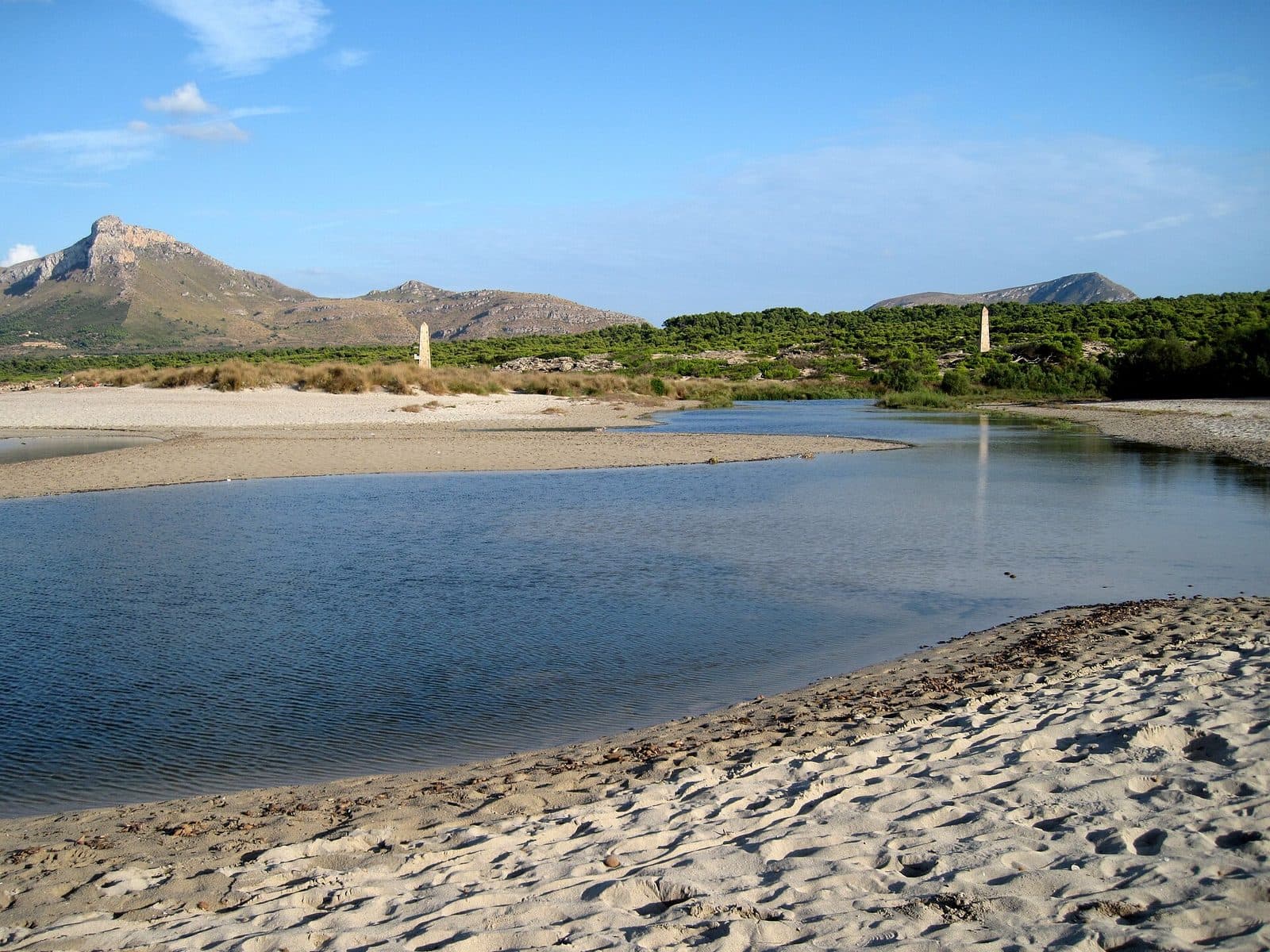

Between the coast of the Badia d’Alcúdia and the foothills of northeastern Mallorca, Torre d'Enfilació appears like an enigmatic sign from another era. Its slender, obelisk-like shape resembles neither a traditional defensive tower nor a lighthouse. That is precisely what makes it intriguing: the monument near Urbanització Sant Pere tells the story of military infrastructure that fulfilled its purpose not on land but on the water.
The Torre belonged to a system of range marks used by the Spanish Navy. Such towers did not stand alone but were read in pairs. From the sea, crews visually aligned two structures positioned one behind the other, creating a fixed bearing line. Combined with other markers, these lines allowed crews to determine their position in the Badia d’Alcúdia and prepare exercises involving mines and torpedoes.
Today, some imagination is required to see the silent monument once again as a nautical instrument. Those who engage with it, however, will discover more than an unusually shaped tower: Torre d'Enfilació reveals how the landscape and coastline were once surveyed. It is particularly interesting for walkers, cyclists, enthusiasts of modern military history and anyone seeking subtle traces of the island's past away from major museums. As an excursion destination, the monument is best understood through close observation, consideration of its location and knowledge of the tower pair that once worked together. A stop here therefore fits best into a walk or exploration of the coastal landscape around Urbanització Sant Pere.
History and significance
The real story of the Torre unfolds, in the imagination, out in the bay. Between the Albufera de Muro and Colònia de Sant Pere, the Spanish Navy built a series of these range towers. Fourteen pairs were constructed in total. They were painted white, numbered and marked in red so that their signals could be distinguished from one another even at greater distances.
The military training area
The structures belonged to the period from 1941 to 1970, when the Badia d’Alcúdia was used as a training area for submarines. During this period, naval units carried out exercises involving mines and torpedoes. The towers were neither gun emplacements nor observation posts intended to repel an attack. Instead, they served as fixed markers that crews could use to navigate on the water.
This distinction is important because the unusual shape is often hastily interpreted as a variation of Mallorca's much older coastal watchtowers. Those historic watchtowers were designed to spot ships and relay warning signals. A Torre d'Enfilació, by contrast, formed part of an optical measurement system. Its purpose did not depend on an extensive view from the structure but on the structure itself being seen from the sea.
Taking bearings through alignment
The Catalan term “enfilació” refers to aligning objects or bringing them into line. One tower stood closer to the sea, with the second behind it. The distance between them was 200 metres. When a ship or submarine was on the intended line, the two markers appeared exactly one behind the other from its perspective. Their visual overlap created a bearing direction; together with other lines, this made it possible to determine the vessel's position.
This also explains why a single tower initially seems incomplete. Its historical function depended on its relationship with a second point and the water. The Torre near Urbanització Sant Pere should therefore be understood less as an isolated building than as a surviving element of a navigational grid once spread across the coastal landscape.
From instrument to monument
After military training operations ended, the range markers lost their practical purpose. Some towers along the bay deteriorated, while others were restored and repainted in their characteristic white and red colours. This striking appearance can also be seen among the surviving examples near Colònia de Sant Pere.
Today, the Torre preserves a chapter of the island's history that is easily overlooked. It commemorates neither a battle nor a famous individual but tells a story of navigation, training and the technical use of an entire bay. This practical origin is precisely what makes it remarkable: a simple optical method shaped the coastline through widely visible architectural markers.
What to see
The first thing to stand out is the obelisk-like silhouette. From certain angles, the structure resembles an obelisk; from others, it looks like an oversized sea mark accidentally left behind on land. Ornamentation and representative details play no role. Shape, visibility and unmistakable recognition determined the design.
The obelisk-like structure
Its clear geometry makes Torre d'Enfilació unmistakable. Unlike a traditional round tower, it does not resemble a conventional defensive structure. Its solid, tapering shape was easier to identify from a distance as a fixed marker. Even without knowing its function, it therefore conveys the impression of a landmark.
Different surfaces can be observed on the surviving range towers of the Badia d’Alcúdia. Some display untreated stone, while others have a light-coloured finish with red elements. The white and red colour scheme was not decoration in the usual sense. It increased contrast and helped distinguish the markers from one another. Where paint, stone and weathering meet, the transition from a once-maintained naval marker to a historic relic becomes particularly vivid.
The sightline of the tower pair
The most important “structural element” actually lies outside the masonry: the imaginary line between the front and rear towers. When viewing the monument, it is worth changing position and paying attention to the structure's alignment. Only then does it become clear why range towers were arranged in pairs. From the correct direction, their outlines merged into a single marker for an observer on the water.
Today, this nautical perspective can only be approximated from land. Nevertheless, knowing about the sightline changes how the tower is perceived. It does not stand randomly in the landscape, and its location was not chosen for convenience. Each range marker had to be visible from the bay and form a precise line with its partner.
Colours and markings
Historically, the towers were white, numbered and marked in red. This combination turned similarly shaped structures into distinguishable navigational markers. Anyone who views the Torre merely as a peculiar ruin therefore misses an essential part of the original system: information was conveyed not only by shape but also by colour and numbering.
The striking design also explains why restored Torres d'Enfilació can appear so modern in the coastal landscape. Their clear division of colours does not belong to a contemporary art project but derives from their military markings. The contrast between the Mediterranean surroundings and the strictly geometric structure is an essential part of the impression today.
A monument without a traditional exhibition
The story of the Torre is embedded in its external shape, its position and its interaction with the bay's other range markers. Observing and interpreting it raises questions: Where was the sea from the tower's perspective? In which direction did its partner structure stand? Why did the silhouette have to be so clear?
This reduction can be appealing because it allows visitors to read a piece of technical landscape. A photograph taken from a little farther away usually conveys the shape more clearly than a close-up. Surface details, by contrast, become significant when looking for traces of paint, weathering and the transition between the base and the tip.
Visiting the tower
The external shape is apparent at first glance, but the historical idea behind it takes a little longer to understand. A visit is therefore best begun by looking around. The tower's position relative to the coast, the alignment of the structure and the unobstructed view of its silhouette explain the monument's function.
A stop worth a second look
Visitors who take photographs, mentally trace the bearing line and include the monument in a walk can explore it in greater depth. It makes sense to begin by viewing the overall shape from a distance and only then focus on colour, material and weathering.
Engagement with the structure therefore depends less on its size than on an interest in its function. Without historical context, it remains an enigmatic obelisk. With knowledge of the submarine exercises and paired alignment system, the same structure becomes an instrument whose imaginary lines extend far into the bay.
Time of day and visitor numbers
Softer light highlights the edges of the tapering structure and makes it easier to take photographs in which the silhouette does not disappear into harsh backlighting. Anyone combining the tower with a walk should also choose the time of day according to temperature and sun exposure, as weather and light shape the perception of the monument more strongly than they would at a conventional attraction.
Access and current conditions
Opening hours and admission details have not been definitively recorded. It is therefore advisable to check current access before travelling. Any barrier should always be respected. Entering the structure is not necessary to understand the Torre: its historical purpose, geometry and effect as a range marker can all be appreciated from outside.
Getting there and parking
The journey leads to Urbanització Sant Pere in northeastern Mallorca. An important planning note: the following distances and journey times end at the urbanisation, not directly at the foot of Torre d'Enfilació. The final section depends on the access chosen locally and should be understood as an orientation stage on the way to the monument.
From Palma Airport
From Palma Airport, the route follows the Ma-15, then the Ma-3322 and the Ma-3331. Urbanització Sant Pere is 72 road kilometres away, and the journey takes around 65 minutes. The Ma-15 covers the long section across the island before the smaller roads lead towards the northeastern coast.
For the final approach, the slender silhouette may help with orientation. The Torre is located near Urbanització Sant Pere. Vehicles should only be left in permitted places, with entrances and narrow passages kept clear.
From central Palma
From central Palma, the route also follows the Ma-15, Ma-3322 and Ma-3331. The journey to Urbanització Sant Pere covers 75 road kilometres and takes around 72 minutes. Here too, both figures expressly refer to the urbanisation. Additional local orientation is then required to find the monument itself.
Anyone making the journey for more than just the tower can combine the visit with the coast and Colònia de Sant Pere. This suits the character of the monument better than a long round trip for a single photo stop.
By bus
The relevant nearby stop is called Talaiot de sa Nineta. The current connection should be checked before travelling.
Bus lines to Torre d'Enfilació at a glance
| Line | Route | Departures/day | First | Last |
|---|---|---|---|---|
| 316 | Son Serra - Inca | 68 | 06:25 | 22:55 |
From the official GTFS feeds (TIB/SFM), no real-time data. The figures cover all stops in the town; weekend and holiday services differ — check with the operator before travelling.
Getting there by bus
Son Serra centre (55044) · 1.0 km as the crow flies
- 316Son Serra - Inca · Daily
Talaiot de sa Nineta 2 (55041) · 1.8 km as the crow flies
- 316Son Serra - Inca · Daily
Talaiot de sa Nineta 1 (55042) · 1.8 km as the crow flies
- 316Son Serra - Inca · Daily
Timetable data: official GTFS feeds (TIB/EMT), no real-time — check with the operator before travelling.
Nearby places
The Torre is best understood through its surroundings. Without the Badia d’Alcúdia, the view from the water and the series of other range markers, it would merely be an unusual solitary structure. Urbanització Sant Pere provides the present-day starting point, but historically the tower belonged to a system extending along the coast between the Albufera de Muro and Colònia de Sant Pere.
Urbanització Sant Pere
The urbanisation is not a staged museum landscape. Residential streets and proximity to the coast form the monument's everyday setting. This is precisely what makes the stop interesting: a relic of military navigation now stands in surroundings whose current use has little connection with its original purpose. For planning purposes, the visit should be approached as a discovery along the way. Its appeal comes from the contrast between the geometric structure and its present-day neighbourhood.
Colònia de Sant Pere
Colònia de Sant Pere is a natural next point of reference for a longer stay. The coastal town has a harbour, a beach and opportunities for walks by the water. From there, the role of the bay becomes particularly easy to understand: the broad expanse of water was once more than a backdrop; it was the space from which the towers were read.
Spending time on the coast also helps reverse the bearing method in the imagination. On land, visitors see one tower and look for its partner. On the water, however, crews searched for the correct perspective until two markers aligned. This simple reversal often makes the historical function easier to understand than a technical description alone.
The range towers of the Badia d’Alcúdia
Other Torres d'Enfilació survive near Son Serra de Marina, on the public Finca Son Real and in Can Picafort, among other places. They should not be confused with the Torre near Urbanització Sant Pere, but they help explain the wider system. Some display natural stone, while others have been restored in their historical colours.
Anyone who encounters several of these relics on a coastal tour will recognise the recurring shape and understand that they are not isolated curiosities. A detailed inspection of every tower is unnecessary. Simply comparing different locations reveals how widely the former range network extended across the bay.
The place it belongs to
Urbanització Sant Pere in the place guidePractical information for your visit
Torre d'Enfilació calls for realistic expectations. Its defining features are its obelisk-like shape, its location and its historical function as a range marker for the Spanish Navy.
Footwear and weather
Local conditions should be considered when planning a visit. There is no need to touch the Torre to appreciate its shape; a viewpoint at some distance usually provides a better overall impression.
Visiting with children
For children, the bearing method can become the main experience. From the perspective of a submarine, two towers had to appear one behind the other so that they visually overlapped. This task can be explained clearly, turning the stop into a small exercise in perspective and navigation.
At the same time, the Torre is not a playground. Children should be supervised near the structure and roads. Barriers mark boundaries and should not be treated as invitations to find a way around them.
Photographing the tower in context
A frontal close-up shows the material and surface but rarely explains the function. A more informative image includes the entire tower and part of its surroundings. Side lighting emphasises the edges of the obelisk-like shape, while a greater distance reveals why the silhouette was easy to recognise from the sea.
Those looking more closely should consider the historical logic of the colours: white provided brightness, while red markings and numbers distinguished the individual range markers. Even where weathering has changed the original appearance, the strictly functional design remains legible.
What the Torre is not
Torre d'Enfilació is neither a medieval defensive tower nor a lighthouse. It should also not be equated with other range towers of the same name around the Badia d’Alcúdia. The name describes a building type found in several locations; this page refers exclusively to the monument near Urbanització Sant Pere.
For visitors, this distinction is more than a historical detail. What stands here is a technical monument from the previous century—simple, enigmatic and fully understandable only through its invisible lines across the bay.
Local insider tips
View it from a distance first
The obelisk-like shape is easier to read from a little farther away than directly beside the structure. A photograph including the surroundings also shows why the Torre could function as a range marker visible from afar.
Look for the invisible line
The tower formed part of a pair. As you change position, consider its alignment with the coast and its former partner structure—the imaginary sightline is what explains the name “Enfilació”.
Use side lighting
Softer light falling from the side defines the edges of the tapering structure more clearly. This allows its strict geometry to stand out better in photographs than it would in harsh frontal light.
Combine it with Colònia
The individual tower is a brief stop. Combined with Colònia de Sant Pere, its harbour and the coast, it becomes a well-rounded excursion that makes the former use of the Badia d’Alcúdia easier to imagine.
Notice the colour system
White paint, red markings and numbers were not merely visual details. They made the similarly shaped range towers distinguishable from the water and formed part of the navigational system.