
Mallorca's climate zone: Csa and the island's microclimates
Ask about the weather in Mallorca and you will often get a single figure by way of answer – yet climatically the island is anything but uniform. In technical terms, Mallorca's climate can be pinned down precisely: it belongs to the Köppen-Geiger zone Csa, the warm-temperate, summer-dry climate with hot summers found around the Mediterranean and in comparable regions of the world. But this one formula describes only the island's average, as measured at the Palma station. Anyone who compares the Serra de Tramuntana, the central lowland of Es Pla and the coastal fringes will find three noticeably different climate zones packed into a small space. This article explains why Mallorca counts as Csa, how the mountain range in the north-west shapes the weather of the whole island, and what that means in very practical terms for visitors.
The Köppen classification: Mallorca is Csa
The Köppen-Geiger classification is the most widely used system for sorting a location's climate into one of a handful of main groups based on long-term temperature and precipitation averages. For Mallorca the formula is Csa, and each of the three letters stands for its own clearly testable condition, one that can be traced directly in the island's measured values.
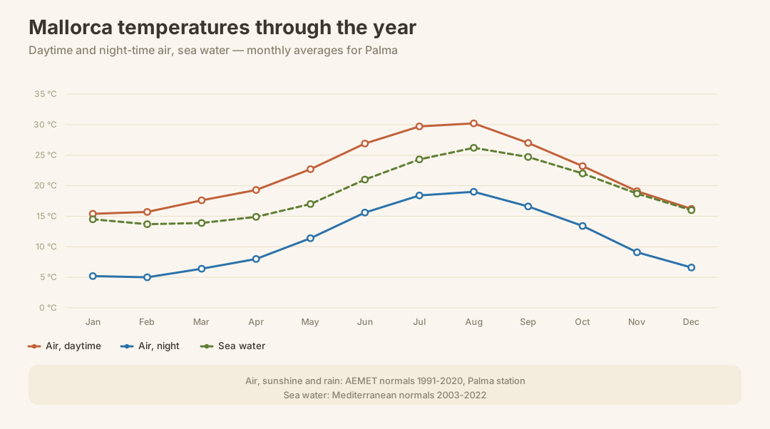
The first letter, C, denotes a warm-temperate climate: the coldest month must not fall below a certain frost threshold on average, while there must also be warm months lying well above it. Mallorca clearly meets this. In January, the coolest month of the year, the average temperature is 10.3 °C, while the annual mean reaches 16.6 °C. That is a world away from real winter in the sense of cold or temperate-continental climate zones – mild winters are typical across the whole island, even if things look different up in the mountains.
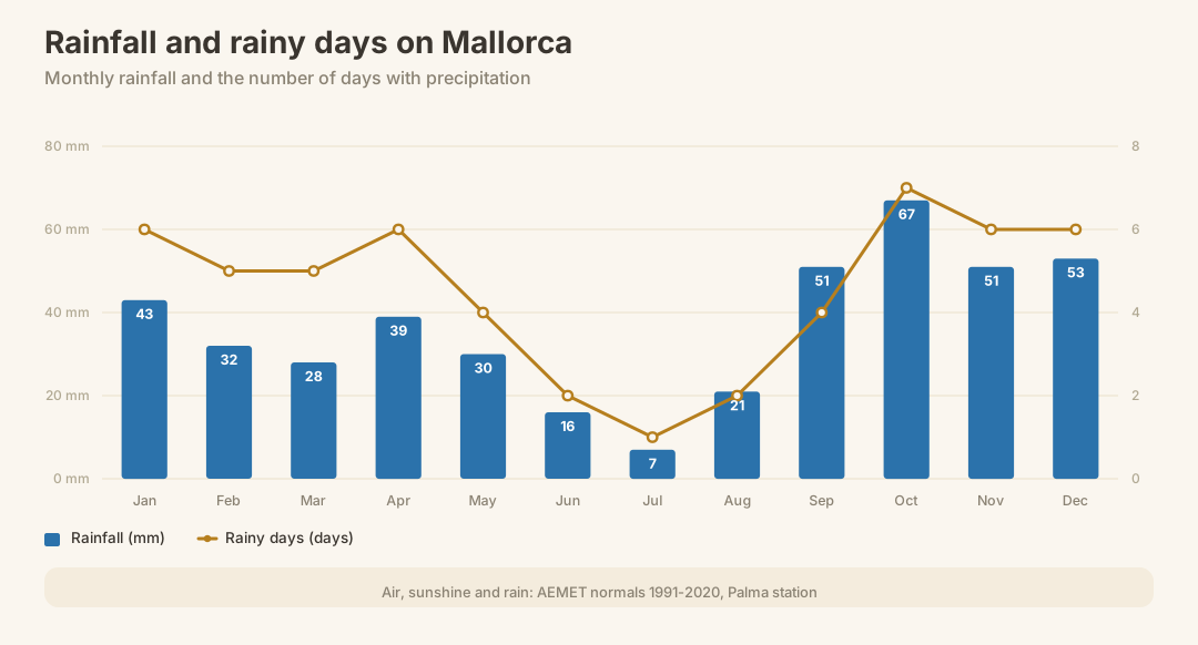
The second letter, s, stands for summer-dry. This refers to a pronounced shift of rainfall into the cold half of the year: the driest summer month receives only a fraction of what the wettest winter month gets. On Mallorca this shows up clearly: in July only 7 mm falls, while October, with 67 mm, ranks among the wettest months of the year. This reversal of the rainfall pattern familiar from Central European summers is the true hallmark of Mediterranean climate zones.
The third letter, a, marks the hot summer. This requires the warmest month to exceed a clear threshold on average. August, Mallorca's hottest month, averages 24.6 °C and comfortably clears this mark. This is what distinguishes Csa from its cooler sibling variant Csb, found for instance along parts of the Atlantic coast or at higher elevations.
Only a handful of regions worldwide share this same combination of mild, rainier winters and hot, dry summers: the rest of the Mediterranean, from southern Spain through southern Italy to Greece, parts of California, South Africa's Cape region, central Chile and south-western Australia. That Mallorca belongs to this exclusive group explains much of what visitors experience as typically Mediterranean about the island – but it also means that summer drought and occasional water shortages are a structural feature of the island, not just something that happens in individual years.
The island's three climate zones
All the figures given on this page come from the Palma weather station and thus describe the climate of the coastal plain in the south-west. That is not a coincidence but simply the only continuously verified measurement series for the island – yet it also means that these figures capture only one of Mallorca's three very different climate zones.
The first zone is the Serra de Tramuntana in the north-west, which runs like a wall along the coast. Here noticeably more rain falls than in the rest of the island, because the mountains force moist air coming off the sea to rise. Nights in the valleys, and even more so along the ridges, are cooler than on the coast, and in the highest reaches around the Puig Major it can snow during the winter months – a sight one does not expect on an island known for summer heat, yet it occurs for a few days in almost every year. Places such as Sóller or Deià sit climatically closer to a temperate mountain climate than to the Playa de Palma, despite being only half an hour's drive away.
The second zone is Es Pla, the central lowland between the mountain ranges. Here the moderating influence of the sea is almost entirely absent, which shows up above all in the swings between day and night temperatures: Es Pla records the greatest differences between day and night anywhere on the island, and usually also the highest peak values on summer days, because the air above the land heats up unchecked during the day and cools down again just as unchecked at night. Towns such as Sineu or Petra lie right in the middle of this zone.
The third zone comprises the coastal fringes around the island, Palma among them. Here the sea acts as a huge temperature buffer: it stores warmth in summer and releases it slowly again in winter, softening extremes in both directions. The sea temperature, which stands at 26.2 °C in late summer, also means that mild evenings by the coast remain possible well into autumn, while inland it is already noticeably cooler at the same time of year.
Anyone planning their trip solely on the basis of Palma's figures regularly underestimates just how different a day in the mountains or in the middle of Es Pla can feel. For a hike in the Tramuntana or a summer's day in Sineu, it is always worth taking a second look beyond the island's general figures.
Why the Tramuntana makes the weather
The Serra de Tramuntana is more than a pretty backdrop – it is the main reason Mallorca's weather divides into zones at all. The mountain range sits like a barrier between the open sea to the north-west and the rest of the island, and this position alone decides where the rain falls and where it does not.
When moist air flows in from the north-west off the sea, it meets the mountains and is forced to rise. As it climbs, the air cools, its capacity to hold moisture drops, and the water vapour condenses into cloud and rain. This so-called orographic rainfall is why the north-western flank of the Tramuntana receives markedly more precipitation than the rest of the island. By the time the air has crossed the mountain ridges, it has already lost much of its moisture. On the leeward, south-eastern side, it sinks again, warming as it does so and becoming drier – an effect meteorologists know as the föhn, and one that explains why Palma and the south-east coast stay noticeably drier than Sóller or Fornalutx on the other side of the very same mountains.
This interplay gives its name to the Tramuntana wind itself, which blows from the north-west across the sea and the mountains. In winter it can be cold and forceful, since it is often linked to cold-air outbreaks from the direction of the Gulf of Lion, which sweep across the still relatively warm Mediterranean before reaching the island. This combination of a cold origin and a moist path across the sea means the wind can pick up unpleasantly along the north-west coast, while it arrives noticeably weaker in the lee of the mountains.
The island's south-east coast, around Palma and further east, remains largely untouched by all this. The mountains intercept both much of the rain and the full force of the wind before either reaches the other side of the island. This is the actual mechanism behind what many know as the milder, sunnier Palma climate: not chance, but a direct consequence of the mountains' physics.
Microclimate and what it means for visitors
The physics of the Tramuntana produces a very practical effect: it can be raining in Sóller while the sun is shining in Palma at the very same time, even though the two places are separated by only a few kilometres as the crow flies. The reason lies exactly in what orographic rain and föhn describe – the mountains in between decide which side gets the rain and which gets the dry, often sunnier air.
For visitors this means, above all, that a single weather forecast for “Mallorca” tells you little once a trip into the mountains is on the cards. Anyone hiking in the Tramuntana is moving through a different climatic world from someone lying on the beach: cooler temperatures, more wind, clouds building up faster, and, in the cold season, the possibility of rain or, at the highest elevations, snow, while beach weather prevails on the coast at the very same hour. It is therefore always worth packing an extra layer of clothing and weatherproof gear for mountain excursions, even if the day began mildly by the sea.
The vegetation follows the same pattern. The almond blossom, for instance, one of the island's best-known images of spring, typically appears earlier in the warmer south and along the coastal plains than in the cooler reaches of the Tramuntana, where the trees follow only after some delay. Anyone chasing the blossom can make use of this difference and adjust their route by region rather than relying on a single island-wide date.
The same principle applies to the swimming season: coastal stretches benefit from the moderating sea and stay milder even in the evening than the surrounding inland, while places in the interior of Es Pla grow hotter by day but cooler by night. Anyone travelling to Mallorca outside the main season would therefore do well to look not just at the calendar but also at the particular region – the microclimate often shapes the experience on the ground more than the month of travel alone.
Climate change: drier, hotter, less Tramuntana
The figures on this page describe a verified state over a fixed reference period – they show what Mallorca's climate actually was during that period, not how it is changing. A serious statement about a trend would require comparing several such periods, and that is deliberately not what this page provides. What can be said, however, is the direction in which the climate of the western Mediterranean is moving, according to consistent scientific assessment, and Mallorca is not exempt from this.
The first direction concerns temperature: both average values and summer peak values point, over the long term, more upwards than downwards. This shows up less as dramatic single events than as a gradual shift – slightly milder winters, and somewhat hotter, above all longer-lasting, hot spells in summer.
The second direction concerns precipitation, or more precisely its distribution. The tendency is towards longer dry spells between rain events, while individual rainfall events, when they do occur, tend to be more intense rather than spread out as steady, gentle rain. This combination of greater average dryness with heavier rainfall in individual cases is typical of the development expected for the Mediterranean region as a whole.
The third direction concerns the sea itself, which is warming – with consequences for the swimming season, but also for the intensity of late-summer storms, which can draw extra energy from warm sea water.
The fourth, less well-known direction concerns the Tramuntana wind itself: various studies suggest that the large-scale weather patterns driving the wind are changing in frequency, with the result that classic, long-lasting Tramuntana spells could become rarer. For the island this would be a double-edged effect – less of the unpleasant wind, but also less of the orographic rain that feeds the mountains and their groundwater.
The climate zone in comparison
Mallorca's Csa climate shares its essential characteristics with a number of regions that might seem to have little in common at first glance, yet follow the same pattern of summer-dry, warm-temperate weather. Sicily and much of southern Italy, for instance, experience the same rhythm of rainier winters and largely dry summers, as does Andalusia in southern Spain, where the summer drought is pronounced and in places lasts even longer than on Mallorca. Parts of Greece, too, particularly the Aegean islands and the Peloponnese, follow the same basic pattern of mild winter rain and hot, practically rain-free summer months.
Outside Europe, the same climate zone appears along parts of the Californian coast, where the ocean likewise provides a certain balance while the interior swings to far greater extremes – a pattern not unlike the relationship between Mallorca's coast and its interior, only on a larger scale.
What sets Mallorca apart within this group is less the basic climate zone itself than the ratio of land to sea within a very small area. Andalusia or California have large, climatically self-contained inland regions that are barely touched by the sea's influence any more. On Mallorca, by contrast, there is practically nowhere far enough from the coast to escape that influence entirely – with the exception of precisely those mountain ranges which instead generate their own, cooler climate through altitude. This compactness, several climatic characters packed onto one small island, is what distinguishes Mallorca from most other Csa regions, even though the basic ingredients – dry summer, mild winter rain, a moderating sea – are the same everywhere.
Frequently asked questions
What climate zone is Mallorca in?
What does a Mediterranean climate actually mean for Mallorca?
Are there regional climate differences within Mallorca?
Why are summers so dry in Mallorca's Mediterranean climate?
How mild are Mallorca's winters really?
What's on in Mallorca in October
- Day Ø 18.3 °C
- Sea 22 °C
- Rain days 7
- Sun 6.4 h
- Daylight 10.9 h
Events
- Exhibition «Voices of the south India-Nepal, and other perspectives»Valldemossa
- Sunday FITZPalma
- Workshop: La MinyoniaCampanet
- Night of the churchesFelanitx
- Show «The best of Jaime Gili»Petra
- Reading clubBunyola
Worth doing now
- Compare the Tramuntana's cooler, wetter microclimate against the drier southern coast before planning a trip.
- Use the mild winter for a city break rather than waiting for the busier, hotter summer.